Está aquí: Inicio » Caminatas » Trekking Santa cruz
SANTA CRUZ TREK
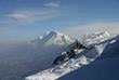
Es una experiencia maravillosa en la Cordillera Blanca; en ella puede disfrutar de la naturaleza pasando por una altura máxima de 4786 metros sobre el nivel del mar, el paso punta Unión, desde donde es posible ver un paisaje espectacular con las montañas: ARTESONRAJU, ALPAMAYO, QUITARAJU, JANCARURISH, PUKAJIRCA, PIRAMIDE GARCILAZO, TAULLIRAJU, LOS NEVADOS Caraz, casi todas ellas sobre los seis mil metros sobre el nivel del mar.
El senderismo Santa Cruz en uno de los circuitos de la naturaleza andina más representativo porque en pocos días se puede apreciar la belleza inconmensurable del Parque Nacional Huascarán sin mucha dificultad.
Santa Cruz - Llanganuco
Duracion: 4 dias
Meses: Abril - Noviembre
Dificultad: Facil / Moderado
Acceso: Cashapampa
Salida: Quebrada Llanganuco (retorno a Huaraz)
Altidud Minima: 2900m Cashapampa
Maxima Altura: 4767m Portachuelo
ITINERARIO
| Dia 1 |
Huaraz - Cashapampa (2900m) - Llama corral (3750m) |
| Dia 2 |
Llama corral - Taullipampa (4250m) |
| Dia 3 |
Taullipampa – Paso Punta unión (4750m)- Cachina pampa (3750m) |
| Dia 4 |
Cachina pampa - Vaquería – Portachuelo of Llanganuco (4750m) - Huaraz |

Santa Cruz – Ulta
Duracion: 6 Dias
Meses: Abril - Noviembre
Dificultad: Facil / Moderado
Acceso: Cashapampa
Salida: Quebrada Ulta (Retorno a Huaraz)
Altidud Minima: 2900m Cashapampa
Maxima Altura: 4767m Portachuelo
ITINERARIO
| Dia 1 |
Huaraz - Cashapampa (2900m) - Llama corral (3750m) |
| Dia 2 |
Llama corral - Taullipampa (4250m) |
| Dia 3 |
Taullipampa – Punta unión Pass (4750m) - Cachina pampa (3750m) |
| Dia 4 |
Cachina pampa - Colcabamba – Mirador (Quebrada Ichic Ulta) |
| Dia 5 |
Mirador – Yana yacu Pass (4850m) – Lake Yana yacu (4600m) |
| Dia 5 |
Lake Yana yacu – Ulta - Huaraz |
« Volver
SOUTH OF HUARAZ
Chavín de Huántar archaeological site
Geographic Location
Chavín is located at the beginning of a narrow valley formed by the Pukcha or Mosna River, which originates from the melt water of the Cordillera Blanca and runs down to the Marañón River, one of the tributaries of the Amazon.
It lies in the heart of the Andes at 3180 meters above sea level, forming part of the so-called Callejón de Conchucos that runs from south to north. Two mountain ranges, the Cordilleras Blanca and Negra, separate Chavín from the ocean and two other chains separate it from the Amazon jungle. The central one rises between the Marañón and Huallaga drainages and the eastern one separates the waters of the Huallaga and Ucayali rivers. This geographic situation creates a series of difficulties for communication among resident human populations, whose relative proximity is mediated by the altitude and the irregularity of the terrain.
This is the birthplace of early civilization. A visitor leaving Chavín de Huántar may feel a complex sensation that is a mixture of emotion, stupor and magic, not only for having come in contact with one of the most powerful and sensitive archaeological centers, but also because Chavín is capable of transmitting a unique vision of our identity, history and strengths.
As great and imposing as Machu Picchu, Chavín de Huántar is an archaeological complex built by the Chavín culture more than three thousand years ago. Declared to be a world heritage site by UNESCO in 1985, the monument is composed of impressive stone constructions with enigmatic interior galleries. Its stone carvings consist of tenoned heads, incised stone slabs and hydraulic canals. The enigmatic Lanzón shows fine technique, a heightened aesthetic sense and, above all, a refined sense of cult and spirituality.

 Ubicacion geografica de nuestros Nevados y Cumbres
 Paquetes de visita al Parque Nacional Huascaran
 Jr. Pedro Cochachin 357, Huaraz - Peru
 Email: ventas@turismoandino.com.pe
 Telefono: (0051) 43 - 421662